
Around the World in Four Years: Homeschool Geography
In my last blog post I talked about my preference for a top-down approach to geography, focusing broadly on global geography and then narrowing down to your country, state, and city as you study the physical and political aspects of each continent. So, what does this look like if you want to help your kids learn geography? Here are some practical ideas.
When we started homeschooling, my goal was to complete a four-year cycle through history, science, and geography. I admit that it was a challenge to stick to my four-year schedule, mostly because of my love for good books. We ended up reading a lot of extra books and digging more deeply into many topics in history and science, which made our overall progress through each subject slower than I would like. My first four-year cycle stretched into a six-year cycle. For geography, the plan was to do an overview of continents and oceans and then focus on one or two continents each year to coincide to some degree with our study of history, as suggested by The Well-Trained Mind (Bauer & Wise). We began with studying Africa and then Asia. This was followed by Europe, Australia, and Antarctica. Finally, we completed the cycle studying North and South America.
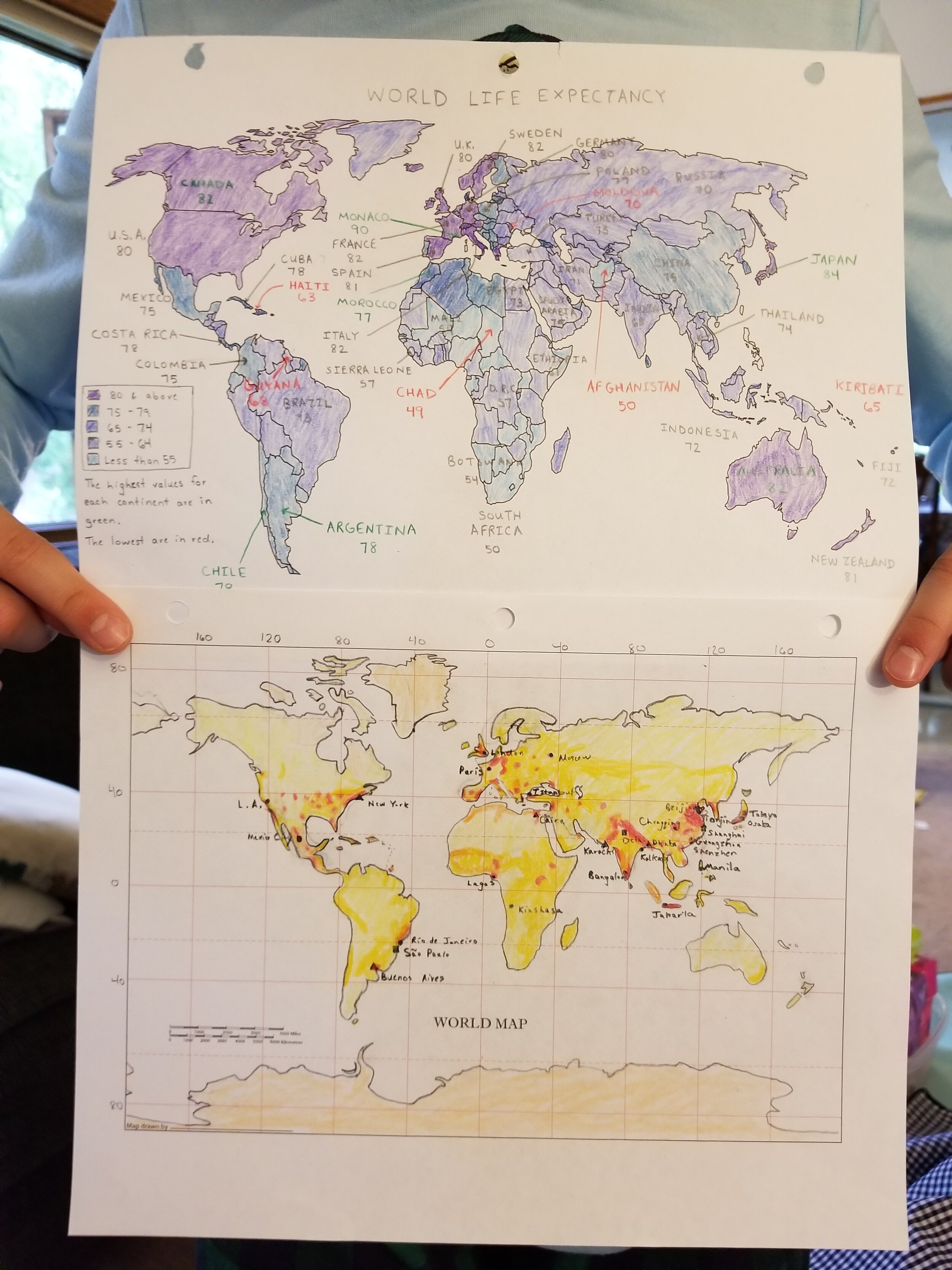
My son enjoys making unique maps. Above: Life-expectancy map. Below: Population density map.
This year we restarted our “four-year” cycle and I’m hoping to stick to the four-year plan, or maybe even complete the cycle in three years. (Yes, that probably isn’t very realistic, but a girl can dream.) Because we are at the beginning of the cycle, we are doing an in- depth unit on maps. This is mostly review for my older kids, but is entirely new for my little guy. It is a challenge to juggle three kids with varying ages, but so far we are managing fairly well. I’ve had some nice discussions with my older kids about how they can improve their mapmaking skills while I read some pretty basic map books with my little guy. For learning about maps, I suggest starting with how to read maps and exploring different types (physical, political, topographic, climate, weather, road, etc.). You will have to gauge how much information to provide based on the interest and abilities of your children.
My older children will also review latitude and longitude. Very young children aren’t typically ready to study longitude and latitude, as they usually haven’t yet mastered necessary number concepts such as place value, but you can provide basic information about the equator, the prime meridian, and directions from these markers. For children who have the requisite knowledge of numbers, latitude and longitude can be a lot of fun. They enjoy challenges such as racing to see how quickly they can find a location on a globe when you give them coordinates. Some parents dislike using workbooks, and I imagine some kids detest them, as well. I’ve never had this problem with workbooks. Honestly, my kids actually like workbooks. I have found that some workbooks are helpful for learning about maps. For younger children, we have used The Complete Book of Maps & Geography. The material in this workbook is recommended for grades 3-6, but I find the material to be accessible at an earlier age, especially for children who are good readers. Some sections of the book are better than others, and we don’t go in the order provided in the book. For children who are a little older, we like Map Reading Skills. This is recommended for grades 5-8, but I think it skews to the younger side of this age range.
The next topic we will cover (for beginning geographers) is continents and oceans. As my older children don’t need any review for this topic, I will only cover this with my four year old. I highly recommend puzzle maps to study continents (or countries and states, for that matter). Map puzzles are great for engaging with place names and shapes. You have to really examine puzzle pieces to see how they fit together, and they are a great learning tool. We have a nice Melissa and Doug wooden continents puzzle, but it looks like they have replaced that with a larger floor puzzle that has the same design. Another way to practice continents with a young child is to print off nomenclature cards for continents (Click here for a pdf of continent nomenclature cards). These cards can be used in multiple ways: 1) Match the continent names and images, 2) Print off multiple sets and play Memory, or 3) Make a booklet out of them. Kids will benefit from recognizing the shape of each continent. Flat maps distort Antarctica, and my four year old already pointed this out to me when matching with the nomenclature cards. “Mommy, this isn’t Antarctica. Antarctica is long and straight!” If a child only sees flat maps, it sure seems that way!


While we initially do a unit on maps, we don’t abandon our study of maps as we switch to studying individual continents. Every week, my older kids draw maps of the continent they are currently studying, as well as world maps and other continents they have previously practiced so they can maintain their skills. Because this is our second round through geography, my oldest son has now learned how to draw an outline map of every continent from memory, as well as an outline map of the entire world. Each time they draw an outline map, they add more features to it. At this point, their ability to draw world maps and continent maps far surpasses my own ability. For the blank latitude and longitude grids for drawing world maps and maps of each continent, we use MapTrek (also available as a downloadable ebook). We mainly use this program for its vast supply of historical maps that we include in our history studies, but they also have current maps and blank grids that are very useful.

A world map from memory! The lighter lines show where my son drew his world map; the darker lines show the actual boundaries.

Although she is two years younger than her brother, my daughter is making great improvement each year in her world map from memory.
In our first cycle through geography, I let my kids select which countries they wanted to study. About every two weeks, they selected a country from the continent we were learning about and I found library books about the country and folktales that originated from cultures in that region. As we now begin our second cycle, we are using a more extensive lesson plan that breaks Africa into regions. The kids can select which region they want to study and then the order for the countries within that region. We have supplemented our studies of continents with some additional workbooks, including World Geography Daily Skill Builders, Discovering the World of Geograpy: Western Hemisphere, and Discovering the World of Geography: Eastern Hemisphere. While each of these workbooks focuses on continents, the Discovering the World of Geography series also includes a bit more about individual countries. These are all suggested for kids in middle-school, but I think World Geography Daily Skill Builders is better suited for kids in grades 4-5. The Discovering the World of Geography series also has two additional workbooks on basic geography and United States geography, but we have not used those.
For my kids, the highlist of studying different countries has probably been the inclusion of folktales and, as the kids get older, other literature set in the countries we are studying. Kids are fascinated by reading literature and hearing tales that come from other places and cultures, and they remember more about each culture when they connect with people in stories.
I have always included music as part of our geography studies. I highly recommend the music compilations of Putumayo Kids. Your local library may have some of their CDs, as well as other world music CDs that can enhance your studies of different countries. As we renew our studies of Africa, I am also planning on using more videos for the second round of geography studies. I have greatly limited television viewing for my children, but some programs are quite useful. Videos of different places allow us to visually engage with the landscape, the people, and the wildlife and provide a deeper level of connection than we can get from reading texts. We are looking forward to watching wildlife videos from different biomes in Africa.
There are many books that suggest activities and projects you can complete to enhance your geography studies. I admit that I haven’t always done the best job with this part of geography lessons. I am hoping to include more projects in round two! We have done a better job using puzzles and games to accompany our studies. My kids LOVE GeoPuzzles and I highly recommend the entire set of six puzzles (including World, Africa, Asia, Europe, Latin America, and USA & Canada). You can purchase each puzzle separately, but you can also save substantially by buying the entire set. My oldest son and my husband are huge board game enthusiasts. I keep telling them it’s time for them to design some games of their own! There are games that focus on world travel that can help your kids learn geography without really trying. Our favorite geography games are the Ten Days in… games from Out of the Box. Unfortunately they are hard to find now, but there are other fun geography-related board games.

In our geography cycle, we study North America in our final year through the cycle. Because we live in the United States, this is when we worked a bit more on states and capitals, although we didn’t actually need to spend much time on this. Why? Because my kids took it upon themselves to learn it on their own before I got to it! Through puzzles, studies of American history, family trips, and their own interest and exploration, my children had already absorbed this information. If you want to encourage your kids to do the same, give them good puzzles such as the Melissa and Doug USA Map Puzzle and the USA & Canada GeoPuzzle. If you like to take long car trips, I also recommend the Melissa and Doug License Plate Game. My kids have used this on all of our cross-country vacations and have a lot of fun with it. We also study the states we travel through by bringing along books about each state and stopping at state and national parks along our way. I highly recommend exploring your own country and state in person! We have enjoyed visiting many state parks in our home state and have made several visits to our state capitol.

A chilly trio checking out the view from the top of the capitol!
Our top-down approach has suited us very well, and my kids have absorbed countries and capitals at a prodigious rate, gotten very good at drawing maps of each continent, and learned a lot about different cultures. We’ve had a blast learning about the world together, and I hope this post has encouraged you to study geography with your kids, too! If you have any questions about our geography adventures, send me an email.
Stay tuned for my next post, where I’ll share a little about how geography is integrated into some of our other subjects.